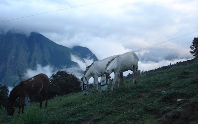
Following my Introductory Post, I shall continue to write hereinafter some more posts on the details of my journey to the Valley of Flowers.
Route covered so far:
Delhi – Haridwar – Rishikesh – Devprayag – Srinagar – Rudraprayag – Karnaprayag – Nandprayag – Chamoli – Pipalkoti – Joshimath – Auli– Govindghat
Delhi – Haridwar – Rishikesh – Devprayag – Srinagar – Rudraprayag – Karnaprayag – Nandprayag – Chamoli – Pipalkoti – Joshimath – Auli– Govindghat
I take a night train from Delhi to Haridwar. Haridwar early morning is enigmatic. Then I embark on an almost 300 kms journey up the mountains that includes a morning stroll and a tuk-tuk ride to Rishikesh and a long bus journey of almost 6 hours via Devprayag and Srinagar to Rudraprayag for an overnight stay in the Government-run GMVN hotel.
The next day, in a ‘sharing taxi’ the rest of the journey from Rudraprayag through scenic Himalayan landscape keeps me spellbound through Karnaprayag and Nandprayag - at the confluences of the beautiful mountain rivers. The tributaries of the Ganges River gives company most of the journey. Reaching Chamoli, and overcoming the landslide episode, I reach Joshimath and have the choice to continue up to Govindghat. But something within me opts to stopover at Auli.
That has been a good decision I must say for the awesome experience in Auli from the time I ascend to the place in a cable car till I return through the same ropeway next morning.
The trekking day begins on a beautiful morning from Auli. The Nanda Devi National Park is about 20 kms away from Joshimath, from where the trek to the Park can begin. A ‘sharing jeep’ that squeezed in about 10 people from Joshimath covers a distance of 21 kms to Govindghat. At each turning I feel like pulling out my camera and shooting photographs. But give up on the thought of doing so from the moving vehicle and then simply begin to enjoy the passing mountain scenery and the cool breeze.
I reach Govindghat and sit down to have some maggi noodles and tea as I am soon to commence the first leg of my journey to the Valley of Flowers by foot. From the window of the tiny roadside restaurant I can see the mesmerizing views of the majestic mountain and it is surprising to see quite a few people in this small mountain town.
I can see most of them are pilgrims who are either: going to or returning from the Hemkund Sahib, holy to the Sikh religion; or on their way to or from Badrinath, holy for Hindus. So Govindghat is an important junction for pilgrims of Hindu and Sikh religion. A minor road branches off as the roadhead towards Ghangaria, so it is an important point also for nature loving travellers like me heading to the Valley of Flowers.
Finishing tea, I walk the one kilometre stretch ambling through shops selling souvenirs, trekking gear, colourful warm clothing and a lot of fancy items to catch the eyes of tourists. I pass through the bridge under which the Alaknanda flows churning its waters into white foam.
The rest of my plan for the day is to ascend a distance of 14 kms from Govindghat to Ghangaria to reach before sunset, and after a night’s rest to trek further right into the Valley of Flowers early next morning.
The rest of my plan for the day is to ascend a distance of 14 kms from Govindghat to Ghangaria to reach before sunset, and after a night’s rest to trek further right into the Valley of Flowers early next morning.
To be continued...
How to Reach Govindghat:
By Air: The nearest airport is the Jolly Grant Airport in Dehradun at a distance of approximately 270 kms.
By Rail: Rishikesh is the nearest Railway Station to Joshimath, which is at a distance of 250 kms connecting to all the major cities of India.
By Road: Govindghat can be reached via Joshimath which is well connected by surface network with Dehradun, Haridwar, Rishikesh and Nainital.
By Rail: Rishikesh is the nearest Railway Station to Joshimath, which is at a distance of 250 kms connecting to all the major cities of India.
By Road: Govindghat can be reached via Joshimath which is well connected by surface network with Dehradun, Haridwar, Rishikesh and Nainital.


